July 7, 2018 Mumbai, Maharashtra, India
Monsoons have just set-in in the country and already news of deaths related to potholes, has started pouring. According to reports, more than 10,000 people die on Indian roads due to accidents caused by potholes and speed breakers. This is just the number of people who lose their lives, the number of injuries caused by such menaces on the roads may be much higher.
While there are many navigation apps available for users, such as Google Maps, Apple Maps, MapMyIndia etc; none of them are able to provide alerts to users about road surface conditions, which could help users take corrective action. Just imagine, if your navigation app could alert you 100 meters before a speed breaker, to slow your vehicle down! Would that not be great?
With this vision of providing users with alerts on road surface conditions, three engineers started working on a technology that could automatically find potholes and speed breakers on roads and subsequently alert other users driving on the same road. “One of the first things that we decided as a team, was that we would need to use automated means for this data collection rather than manual”, said, Tabrez Alam, the Founder of Intents Navigation.
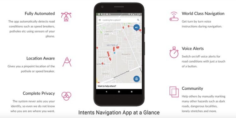
The technology uses the most common device found with all of us now, which is the mobile phone. As a user drives around with the mobile phone in the car or any vehicle, the sensors of the mobile phone keep measuring the acceleration experienced by the mobile phone. This data is then sent to a central server which gathers data from all such mobile phones, and by using statistical analysis, finds out the locations of the potholes and speed breakers. This information is then relayed back to all users so that the app starts alerting them as they approach any such condition on the roads.
The Intents Navigation app is a complete navigation app in itself with all standard features which you need to use during navigation; such as address search, turn by turn voice guidance and much more. The app can be downloaded free of cost from Google Play Store (https://play.google.com/store/apps/details?id=com.intents.navigation&referrer=utm_source%3Dbw).
“We have been working on this technology for more than a year now and have been able to map a significant number of cities and highways of the country”, said Tabrez. According to him, The core value of our vision is to make roads safer for people, but we are also trying to help businesses and civic agencies. In future, we believe that the information on road surface conditions will become critical for autonomous vehicles as well”.
The team is now working on improving the information on roads by using both automated and crowdsourced methods of providing users with other information such as unlit roads, areas considered unsafe and much more. “We aim to provide a much more holistic information to users as they navigate on roads, rather than just traffic conditions”, Tabrez added.

